Making Space For Water
Making Space for Water
Climate change is causing heavier rainfall and rising flood risks in many regions. Traditional flood defenses like walls and levees are no longer sufficient on their own. Around the world, planners and designers are recognising that certain areas will inevitably flood, and instead of fighting the water, they are embracing it. This approach, often called “making space for water,” marks a shift toward accepting and accommodating floodwaters in our cities and landscapes. By intentionally designing spaces to flood safely, communities can reduce damage while also creating multifunctional and beautiful places for people.
Urban Spaces That Embrace Floodwater
One innovative strategy is to turn urban public spaces, plazas, parks, streets, into dual-purpose areas that serve the community in dry times and store water during storms. A famous example is Rotterdam’s Benthemplein Water Square, the world’s first full-scale water plaza. In normal weather, Benthemplein is a vibrant public square with sports fields (basketball courts, skate areas) and seating for socialising. When heavy rain falls, however, the square’s basins fill up and retain nearly 1.7 million liters of stormwater, preventing surrounding streets from flooding. Once the rain subsides, the water gradually drains and the square returns to its recreational function. This smart design ensures that money invested in flood infrastructure also provides everyday community value.
Rotterdam’s water squares were developed through close collaboration between water engineers, architects, and local residents. For Benthemplein, architects from De Urbanisten engaged students from a nearby school and neighborhood residents to co-design features of the square. The result is a space with greenery, a theatre stage, skate park elements, and sports facilities, all integrated into the water basins. Local input helped make the flood accommodations not only technically effective but also welcoming and fun for the community. Importantly, the floodable sections are clearly delineated (even painted in blue tones) so that people understand where water will go, building public awareness of the flood function. This kind of engagement improves public acceptance of living with water, as residents take pride in a square that both keeps their “feet dry” and enhances the neighborhood.
Cities worldwide are adopting similar multi-use flood designs. In Copenhagen, for instance, cloudburst planning has transformed low-lying areas into attractive water-retention landscapes. Hans Tavsens Park in the Nørrebro district is being redesigned with a series of lush sunken gardens and basins that act as stormwater reservoirs during cloudbursts, but serve as green recreational space in normal weather. A connected street is engineered as a channel that guides excess water to a nearby lake, all while remaining a pleasant, tree-lined boulevard when dry. Crucially, these spaces are meant to remain inviting even during floods, using nature-based designs (terrain shaping, plants, wetlands) instead of unsightly concrete tanks. Copenhagen’s climate adaptation plan explicitly identifies parks and plazas as temporary flood areas to relieve pressure on sewers, reflecting a planning policy that normalizes periodic flooding in designated safe zones. In this way, urban flood infrastructure doubles as public amenity, and citizens come to accept occasional inundation as a planned event rather than a disaster.
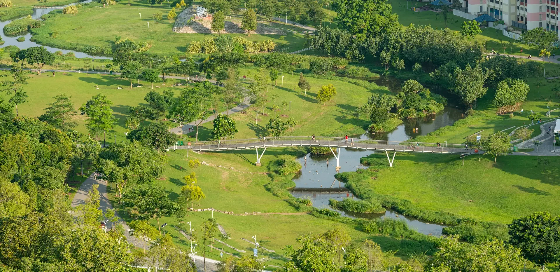
Even urban parks can be designed to accommodate river floods or heavy rains gracefully. A landmark project is Bishan-Ang Mo Kio Park in Singapore, where a concrete drainage canal was replaced with a meandering natural river through a public park. The reconfigured park functions as a spacious floodplain: during torrential rains the river’s edges and adjacent lawns can safely inundate, protecting nearby roads and homes. Once the water level recedes, the park’s footpaths and lawns re-emerge largely unharmed, now enriched by fresh silt and moisture for plants. In dry weather, people enjoy a verdant riverside with wildlife, instead of a fenced-off concrete ditch. Singapore’s national water agency deliberately blended flood control with landscape design here, increasing the channel’s capacity while creating a beautiful natural environment for the community. This project was part of the city’s “Active, Beautiful, Clean Waters” program, highlighting that flood infrastructure can also promote recreation, biodiversity, and quality of life. Tellingly, after the park’s opening, one heavy rain triggered minor flooding exactly as designed – yet some uninformed residents panicked, thinking the park was “destroyed” by floods. Officials quickly explained that the temporary ponding was intentional and the park performed perfectly. This incident shows how public education is vital so that people understand and embrace these “designed to flood” spaces rather than fear them.
Common features are emerging in these floodable urban spaces:
Low-lying basins or plazas set at ground level or below, designated to fill with water during intense rain. They are intentionally located where floodwater can collect with minimal harm (away from buildings or critical infrastructure).
Multi-purpose use in fair weather – e.g. sports courts, playgrounds, amphitheaters, gardens, or markets, so that the space isn’t idle. This ensures investments benefit the community year-round, not just in emergencies.
Durable, water-friendly materials and landscaping that can withstand immersion. For example, concrete or tiled surfaces for plazas, water-tolerant plants in parks, and gently sloping “edges” to contain water. These design choices mean that once water drains, the area can be cleaned up and reopened quickly.
Integrated drainage and overflow paths linking to broader water systems. Urban flood zones are connected to channels, lakes, or rivers so that water can be released or absorbed safely after peak events. For instance, a street might double as a channel to convey excess runoff to a pond or river, as seen in Copenhagen’s cloudburst boulevards.
Community engagement and visibility, making the water’s presence a feature not a flaw. Clear signage or design cues (like colored pavement where water will pool) help residents know what to expect. Involving locals in planning and adding amenities they want (benches, sports facilities, art) builds pride in these resilient spaces.
By incorporating these elements, cities foster a culture of “living with water.” Flood events become more predictable and less disruptive, and people gain new parks and plazas instead of just higher flood walls.
Flood-Resilient Architecture and Communities
Beyond public squares and parks, architects are also reimagining buildings and neighbourhoods to cope with flooding. A leading example is the work of BACA Architects in the UK, who specialise in flood-resilient design. BACA’s projects start from the premise that flooding will occur, so structures and sites must be designed to accommodate that water rather than simply hold it back. One of their most celebrated designs is the UK’s first amphibious house, built on the River Thames floodplain. This house, named Formosa, rests on fixed foundations during normal conditions but is engineered to float upwards on rising floodwater – essentially turning into a boat in extreme floods. The house can safely ride flood levels up to 2.5 meters (about 8 feet) above ground, then settle back down as water recedes. Flexible utility connections and an innovative dock prevent any damage, meaning the residents can stay safe and dry inside even during a major flood. Instead of having to build a stilt-house perched high above ground (which was the old solution), the amphibious design keeps the home at a normal ground level most of the time, preserving aesthetics and access, but provides resilience when nature demands it.
BACA’s amphibious house demonstrates how beautiful architecture and flood accommodation can go hand in hand. The house looks like a stylish modern home, not a utilitarian water tank. It also illustrates the principle of designing for exceedance, planning what will happen when flood defences are overtopped, so the water has a controlled place to go (in this case, under the house, lifting it) instead of causing chaos. Richard Coutts, one of BACA’s directors, noted that ideally whole riverside communities should be planned this way, not just individual buildings. In other words, every element of a development, houses, gardens, roads, open space, can be configured to either resist water or to temporarily give way to it in a safe manner. BACA’s research for the UK government (the LiFE Project – Long-term Initiatives for Flood-risk Environments) outlined exactly such a holistic approach. It called for moving “from traditional flood prevention to a non-defensive strategy”: let water flow through predetermined sacrificial areas, which can serve other purposes like parks or energy production when dry. Buildings in higher-risk zones are made flood-resilient (through elevation, flotation, or waterproofing), while more vulnerable uses are steered to safer zones. This integrated planning creates settlements that can flood gracefully, with minimal damage and downtime.
Other examples of architecture making space for water include floating communities and adaptive buildings. The Netherlands, already famous for water management, has floating neighborhoods such as Ijburg in Amsterdam and experimental floating pavilions. In Rotterdam’s Nassauhaven, a pilot project installed a dozen floating houses on a disused harbor basin, turning underutilized water surface into housing space that naturally rises and falls with the tide. In low-lying coastal cities, architects are exploring designs where ground floors are sacrificial or water-permeable(for parking, plazas, or lobbies that can flood without ruin), while critical living areas sit above anticipated flood levels. These strategies align with the same ethos: accepting water as an occupant of our urban space at times, and planning our structures accordingly. Developers and residents are gradually warming to these ideas as the proof-of-concept projects succeed, showing that one can live safely and comfortably with water. In fact, the cost premium for building an amphibious or otherwise flood-resilient home is dropping as techniques become more common, a sign that mainstream adoption could be on the horizon.
Planning for Resilience and Acceptance
Integrating “living with water” principles into urban planning and policy is crucial for scaling up these solutions. Forward-thinking cities and countries are updating their plans to designate flood accommodation areas and encourage water-resilient design. The city of Copenhagen, after experiencing a devastating cloudburst in 2011, developed a comprehensive Climate Adaptation Plan that identifies parks, sports fields, and plazas to serve as temporary flood reservoirs during extreme rains. This plan works in concert with traditional infrastructure (like sewers and underground tunnels), but crucially it signals political acceptance that surface flooding will happen and can be harnessed to benefit the city. London and other UK cities are similarly incorporating sustainable drainage systems (SuDS) and floodable open spaces in new developments, guided in part by national policy. The UK government’s “Making Space for Water” strategy, first outlined in the 2000s, explicitly shifted flood management towards this kind of integrated, adaptive approach. Rather than relying only on higher flood walls, the policy supports measures like designated washlands, restored wetlands, and porous urban landscapes to manage flood risk in a more sustainable way.
Public acceptance is a key piece of the puzzle. Planners have learned that they must communicate clearly with communities about the purpose of floodable designs. When citizens understand that a football field or car park is meant to hold water on rare occasions, they are less likely to view a temporary flood as a failure. For example, in the Singapore park case mentioned earlier, once people learned the new park’s flood role, they appreciated how it saved their streets from flooding and still provided a beautiful environment afterward. Cities are using signage, education campaigns, and even events to celebrate these water spaces, such as “water plaza festivals” in Rotterdam – to normalise the presence of water. Over time, this nurtures a cultural acceptance that some days your local park might be a pond and that’s okay, it’s protecting your home and will soon be a park again. This mindset shift is comparable to how communities accept that a reservoir or detention basin might occasionally be low or high; in this case the “reservoir” just happens to be a public square or green.
At the broader landscape scale, rural and coastal areas are also being planned to give more room to water, which complements urban efforts. The Netherlands’ Room for the River program is a pioneering example of making space for water in rural river basins. Launched after severe floods in the 1990s, this national program undertook over 30 projects along the Rhine, Meuse, and other rivers to restore natural floodplains and create floodwater storage. Measures included relocating dikes further from the river, lowering overflow areas, and carving new side channels to absorb high flows. While this meant surrendering some farmland and relocating a few communities, it dramatically reduced flood risk for major towns and cities downstream. Importantly, many Room for the River projects also created nature parks, wetlands, and recreational areas in the newly freed floodplain, improving the environmental quality of the region at the same time. In the UK, a similar approach can be seen in initiatives to reconnect rivers with their floodplain in less populated areas, for instance, allowing washlands to flood farmland in a controlled way, or breaching old embankments to restore salt marshes on the coast as natural buffers. These projects acknowledge that it’s sometimes wiser and more cost-effective to let water expand into open land (with compensation or alternative benefits to landowners) than to force it into narrow channels that put towns at risk. By planning at the catchment scale, authorities ensure that rural retention and urban adaptation work together: if rivers can safely spill into fields or designated basins upstream, then downstream urban centers face less extreme inundation. This holistic view, often termed integrated flood management, aligns engineering with ecology and land use planning.
Embracing a Water-Resilient Future
Designing our environments to accommodate floods requires creativity, coordination, and a new mindset, but the payoff is enormous. Instead of catastrophic losses, a big storm can become an event that city parks and plazas handle with grace, temporarily transforming and then bouncing back. Instead of dreary flood defenses, we get lively public spaces that make daily life richer. By making space for water, communities large and small are proving that resilience and quality of life can go hand in hand. Planners, architects, and citizens are learning to see water not as an enemy to vanquish, but as an integral part of the landscape to live with. Achieving this vision means accepting some inconvenience and occasional sogginess, but in return we gain safer cities, sustainable ecosystems, and often a more delightful place to live. As BACA Architects put it, we ultimately have no choice but to live with water; we only have a choice in how we design for it. And by choosing to design with wisdom and imagination, we can create urban and rural environments that truly work with nature’s water cycle, turning flood challenges into opportunities for innovation, beauty, and harmony with our changing climate.